Existing Conditions
NE 410 and I-35 Area Regional Center
Explore the tabs below to learn more about the assets, challenges, and opportunities in the NE I-35 and Loop 410 Area Regional Center and to view our study area map.
The map below shows the NE Loop 410 and I-35 Regional Center Regional Center Area in relationship to San Antonio. The area is highlighted in black.
View Full Size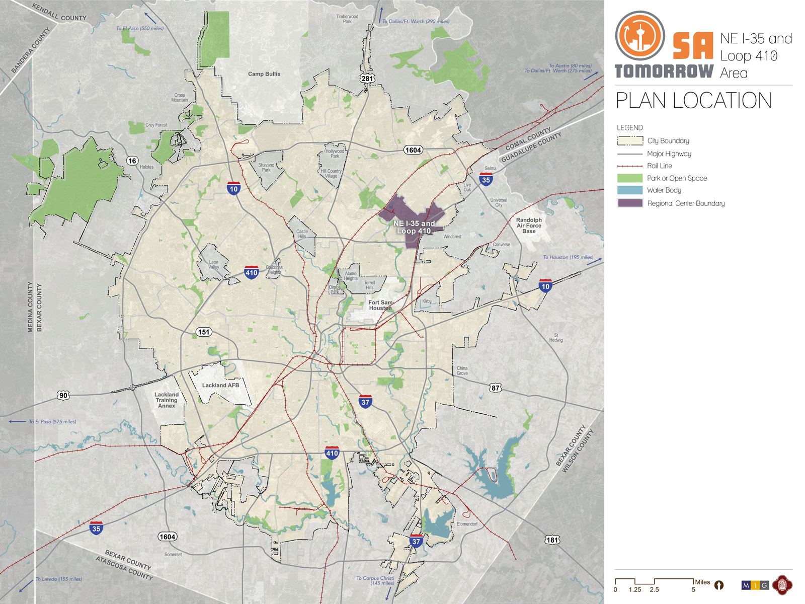
Assets
Highlighted among the NE I-35 and Loop 410 Area Regional Center’s assets are its location within the region; access to major transportation routes; diversity of employment base; and unique mix of anchor businesses, institutions, and entertainment venues. Loop 410, I-35, and Wurzbach Parkway help to move people and goods throughout the region and support robust employment in the transportation and warehousing industries. The Longhorn Quarry redevelopment, anchored by Toyota Field, Morgan’s Wonderland, Heroes Stadium, Children’s Rehabilitation Institute, and new multi-family housing, is a thriving example of adaptive reuse. Residents of the Regional Center also cite its relative affordability, ease of access, and established neighborhoods as major assets

Challenges
As with other established parts of the City, the NE I-35 and Loop 410 area does face challenges related to the changing economy and general disinvestment as businesses and residents choose to locate in more suburban areas. Another consequence of suburban flight is the prevalence of aging, underutilized strip centers lining commercial corridors in the area. Residents have difficulty finding local retail and service establishments that meet their-day-day needs. The growth of surrounding suburban communities also contributes to increasingly congested traffic patterns within the Regional Center. Although TxDOT is in the process of expanding I-35, and has the community’s desire for a direct connection to Wurzbach Parkway on its radar, lack of other modes of transportation will continue to place stress on roadways.
While the highways and rail lines that crisscross the Regional Center do benefit its economy, they also create a disjointed landscape that contributes to an overall lack of community identity. There are few green and open areas within the Regional Center and past development patterns have made connections to adjacent parks and trails difficult.

Opportunities
As mentioned previously, the Regional Center’s location makes it an attractive commercial hub. With an already vibrant transportation and warehousing base, the area is well positioned to capture more of this type of business with the proliferation of e-commerce and its inherent need for efficient delivery networks. In recent years, there has also been a coordinated focus on economic development and reinvestment in the NE I-35 and Loop 410 area. A Tax Increment Reinvestment Zone (TIRZ), federally designated Opportunity Zone, and a commercial property enhancement grant program are financial tools available within the Regional Center to assist with reinvestment efforts. These financial incentives can be used to fund a wide range of projects, from large-scale site redevelopment or corridor-wide streetscape improvements to smaller place-based initiatives such as public art.
.jpg)
The map below shows the NE Loop 410 and I-35 Regional Center Regional Center Area Plan boundary and the connectivity throughout the area and beyond.
View Full Size
Sub-Area Plans
Sub-Area Plans are intended to provide a more coordinated, efficient and effective structure for neighborhood planning. Existing and future neighborhood planning will be integrated into the planning for regional centers and community areas. Neighborhoods will become integral sub-geographies of these sub-areas while also receiving special attention through chapters and/or sections in each Sub-Area Plan, reflecting specific opportunities, challenges, recommendations, and priorities from each participating neighborhood. Neighborhood and community plans should be respected, as appropriate, as they are integrated into the Sub-Area Plans.
Comprehensive Plan Regional Centers
Regional centers are one of the major building blocks of San Antonio’s city form and are a major component of the Comprehensive Plan and the overall SA Tomorrow effort.
While most cities have one or two larger employment centers, we have 13. This provides challenges and opportunities. A major organizing element for the Comprehensive Plan is to focus growth in these regional centers, building on the existing pattern of development. They’re envisioned as new “places” where we live, work, and play.
New development is already gravitating to these centers and we can guide additional growth in these areas. Each center is different and its development will be influenced by its existing uses. However, many of the centers are also well-positioned to develop as vibrant mixed-use places. They offer a variety of housing options and price ranges, allow higher-density and incorporate carefully designed and located amenities that will benefit both residents and employees of the center. Each center’s character can attract a different mix of businesses and employees. Therefore, San Antonio must focus its investment and infrastructure strategies on supporting and leveraging the unique identity and assets of each center.