Plan Framework
Introduction & Approach to Regional Center Planning
Planning for the future of the NE I-35 and Loop 410 Area Regional Center is a complex undertaking with many aspects to consider, such as current conditions, population and job projections, and community goals and priorities. The Plan Framework helps ensure comprehensive consideration of essential elements by organizing the Regional Center Plan into six main topic areas: Land Use, Focus Areas, Mobility, Amenities & Public Spaces, Housing, and Economic Development. When you see the term "Plan Framework" used throughout the Regional Center Plan, it is referring to these six topic areas.
Detailed background information, maps, illustrations, recommendations, and strategies for each of these six topics can be found in their respective sections in the Regional Center Plan. The recommendations and strategies support the overall vision and goals for the Regional Center and are based on existing conditions analysis; research and best practices case studies; collaboration with other City departments and partner agencies and organizations; and many conversations with the Planning Team and the wider NE I-35 and Loop 410 area community.
Plan Framework Overview = Highlights from Land Use, Focus Areas, Mobility, Amenities & Public Spaces, Housing, and Economic Development
While all the recommendations and strategies in the NE I-35 and Loop 410 Area Regional Center Plan are important, the following Plan Framework overview highlights those from each of the Plan’s six main topic areas that were determined to be most critical to achieving the Plan vision and goals; are more likely to be funded and implemented in the short-term; build upon other existing or ongoing initiatives; or are a necessary first step to provide a foundation for other projects and investments.
The Plan Framework overview presents the key highlights in two ways: a list of Implementation Priorities and the Plan Framework Map. The Implementation Priorities list below compiles the priority recommendations and strategies from each of the Plan’s six main topic areas. The Plan Framework Map depicts broad concepts from the Implementation Priorities list in order to illustrate important overlaps, adjacencies, and mutually supportive relationships. Some land use, housing, and economic development recommendations and strategies are not easily depicted on a map, but together, the Implementation Priorities list and Plan Framework Map summarize the key strategic concepts and physical improvements that will influence future development of the NE I-35 and Loop 410 Area Regional Center.
Implementation Priorities List
Land Use
Recommendation 1: Support mixed-use redevelopment at a variety of scales in identified focus areas and along transit corridors.
Strategy 1.1: Where appropriate, rezone properties to a mixed-use zoning district in areas where mixed-use development is desired, particularly in areas designated as Regional Mixed-Use or Urban Mixed-Use. Important areas to consider are the Longhorn Quarry, the Rialto/Galaxy Theater area, and the area north of the VIA Randolph Transit Center.
Focus Areas
Recommendation 1: Support land use and zoning that will encourage redevelopment and revitalization of aging, underutilized, and outdated commercial areas with spaces that meet the demands of modern markets and lifestyles.
Recommendation 2: Examine options for using natural and man-made features, such as floodplains, drainage ways, and utility easements, to expand greenspace, trail connections, and recreational opportunities as well mitigate flooding hazards.
Mobility
Recommendation 2: Complete the multimodal mobility network and establish new connections through partnerships with appropriate local, state, and federal entities.
Strategy 2.1: Conduct a “complete streets” study to find opportunities to reduce pedestrian crossing time, increase pedestrian crossing opportunities, and reduce vehicle operational speeds. The following street segments are ideal for study and implementation:
- Thousand Oaks Drive from Perrin Beitel Road to Bulverde Road;
- Nacogdoches Road from Hillpoint to Wurzbach Parkway;
- Walzem Road from Austin Highway to Cross Creek; and
- Crosswinds Way from I-35 to Wurzbach Parkway.
Strategy 2.2: Implement on-road infrastructure and wayfinding projects to improve first/last mile connectivity to regionally significant trailheads such as the McAllister Park, Lady Bird Johnson Park, Tobin Park Trailhead, and Oakwell Trailhead Park.
Amenities and Public Space
Recommendation 1: Leverage floodplain areas and public easements within the Regional Center to expand green space and create direct connections to nearby parks and greenway trails.
Strategy 1.1: Coordinate with CPS Energy, the Department of Parks and Recreation, the Public Works Department, the Transportation Department and other relevant stakeholders to explore options and feasibility of priority trail connections using public easements.
Strategy 1.2: Require green infrastructure and low impact development as a condition of accepting City incentives for new development or redevelopment projects in the Regional Center.
Housing
Recommendation 2: Support reinvestment in existing neighborhoods and homes.
Strategy 2.1: The City offers several programs to promote and support homeownership, such as the Homeownership Incentive Program, Minor Repair Program, and Green and Healthy Homes Program. Proactively raise homeowner awareness of these programs by engaging homeowners and neighborhood associations. Proactively raise awareness of these programs with potential homeowners by engaging with veteran’s organizations, local colleges and universities, and local employers.
Recommendation 3: Connect and orient neighborhoods and housing to area parks, greenways, and open spaces.
Strategy 3.1: Explore options for retrofitting existing and constructing new drainage ways with green infrastructure. Integrate drainage ways, utility easements, and open spaces into neighborhoods and mixed-use areas to increase connectivity and to preserve the existing natural systems in the area. Require integration of green drainage ways and open space within new development projects. Incorporate improvements to address gaps in open space and storm drainage management in public right of way investments and other capital projects.
Economic Development
Recommendation 1: Explore options for retrofitting existing and constructing new drainage ways with green infrastructure. Integrate drainage ways, utility easements, and open spaces into neighborhoods and mixed-use areas to increase connectivity and to preserve the existing natural systems in the area. Require integration of green drainage ways and open space within new development projects. Incorporate improvements to address gaps in open space and storm drainage management in public right of way investments and other capital projects.
Strategy 1.1: Encourage and support the developer of the Longhorn Quarry area in creating a distinct mixed-use destination that supports major attractions, a strong employment base, and desired amenities within the Regional Center. Ensure that the land use designations and zoning facilitate a mixture of uses and a denser development pattern than found elsewhere in the Regional Center. The City can also provide assistance with available incentive programs, infrastructure needs, and streamlining the development process.
Recommendation 2: Invest in and support revitalization of the existing commercial and industrial areas within the Regional Center.
Strategy 2.2: Continue to encourage reinvestment and redevelopment of aging retail areas through the use of Tax Increment Reinvestment Zone (TIRZ) funding, commercial property improvement grants, and other tools. Outreach to business associations, chambers of commerce, and other entities to encourage targeted uses, such as retail, restaurant, and incubators, to locate in reinvestment areas.
Plan Framework Map Overview
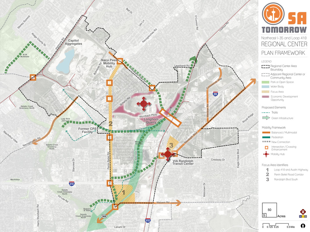
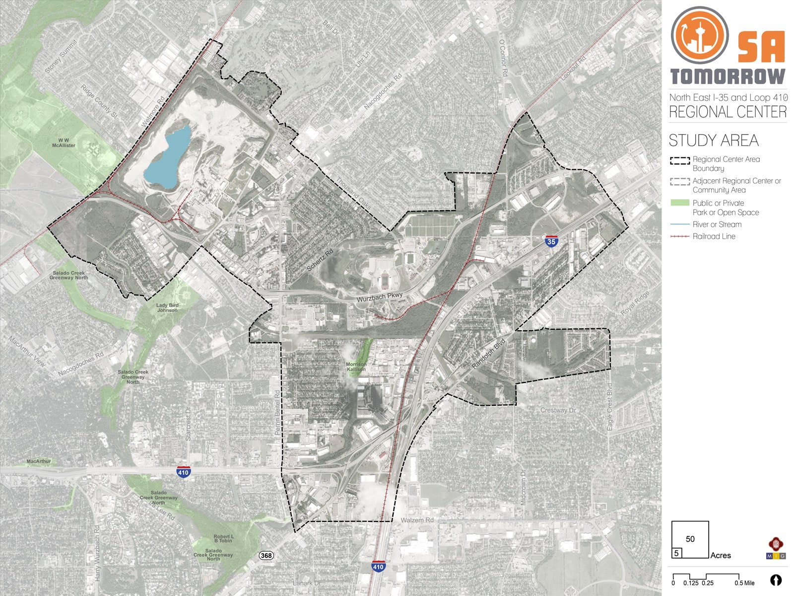
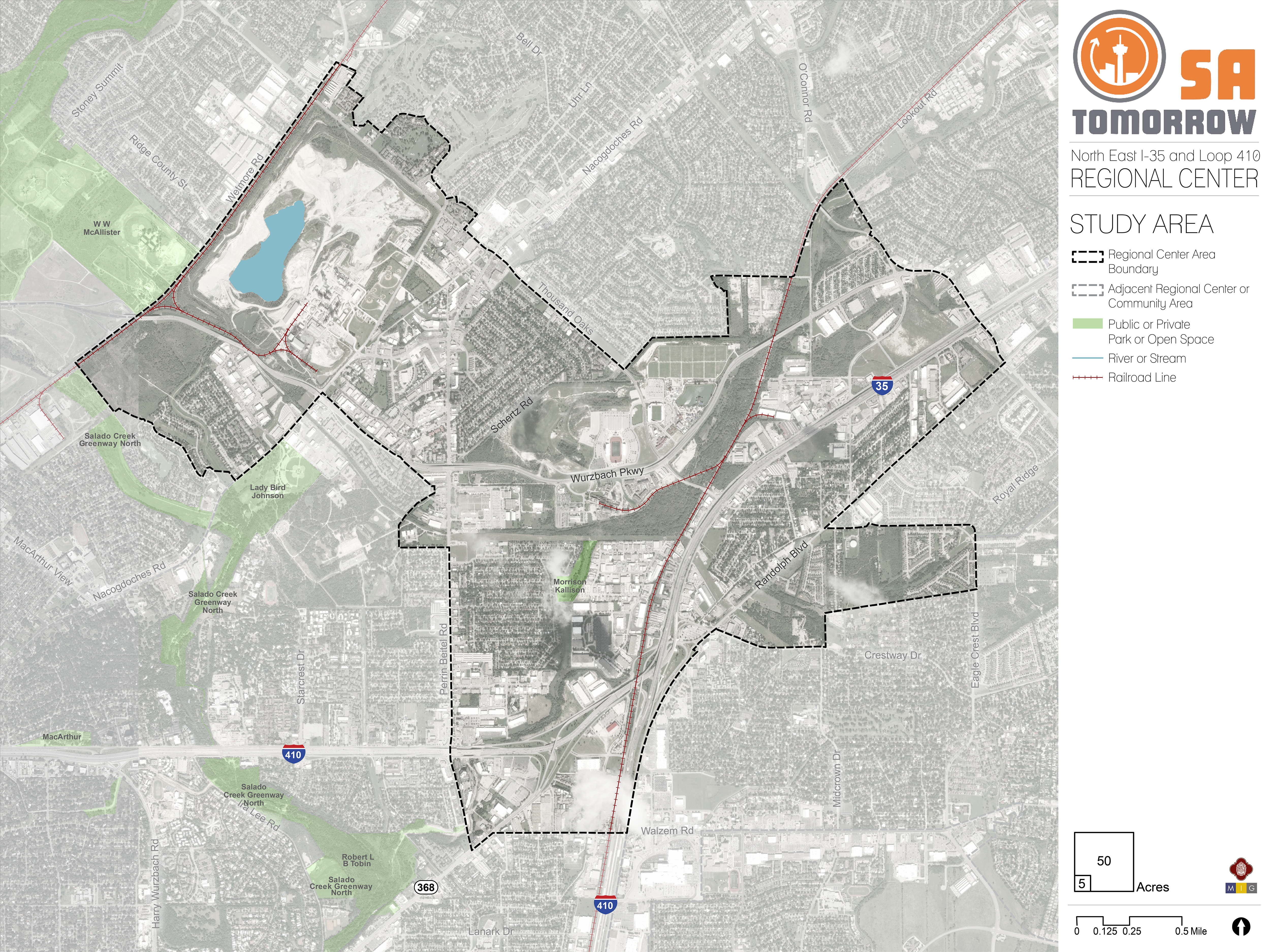
NE I-35 and Loop 410 Area Regional Center Plan Framework Map
The Plan Framework Map illustrates the interrelatedness of key physical concepts from the Implementation Priorities list above. These include the focus areas; economic development opportunities; trail and green infrastructure enhancements; and modal priorities that will help guide corridor design treatments to provide multimodal access and improved pedestrian, transit, and safety facilities. The highlighted Implementation Priorities and Plan Framework Map elements are complemented by other supportive Regional Center Plan recommendations and strategies related to land use, housing, mobility, economic development, and amenities.
Trails and Green/Open Space
Trail connections and more green/open space were proposed throughout the Regional Center, but high priority was given to connections that would provide direct links from the Regional Center to adjacent trailways and parks, such as the Salado Creek Greenway Trail and Lady Bird Johnson Park. On the map, proposed trail connections are located:
- South of Loop 410 along Perrin Beitel to connect the Regional Center to the Salado Creek Greenway Trail;
- Along Beitel Creek through Kallison Park linking to the Longhorn Quarry and;
- Just south of Wurzbach Parkway between the Longhorn Quarry and Lady Bird Johnson Park.
Floodplain areas along Beitel Creek could be used to both expand trails and increase green/open space.
Balanced/Multimodal
Balanced and multimodal corridors are envisioned as “complete streets.” Complete streets are designed to enable safe access for all users including pedestrians, bicyclists, motorists, and transit riders of all ages and abilities. Multimodal enhancement locations are identified as areas where crossing is considered a priority and pedestrians, motorists, and bicyclists share space. Priority corridor and enhancement designation was given to areas where proposed trail connections intersect with or cross major streets. On the map, these areas are located along Perrin Beitel Road, Nacogdoches Road near Lady Bird Johnson Park and the Capitol Aggregates Ballpark, and crossings or routes in close proximity to VIA transit facilities.
Focus Areas and Economic Development
Focus Areas are areas of opportunity that, with strategic planning and investment, could be catalysts for economic development in the future. Because most of the land within the NE I-35 and Loop 410 Area Regional Center has already been developed, revitalization and reimagination of aging and underutilized areas is a dominant theme. Revitalization and reinvestment projects can take many forms and from small-scale streetscape improvements, such as lighting and landscaping, to large multi-parcel redevelopments. Three focus areas were identified for the Regional Center:
- Focus Area 1: Loop 410 and Austin Highway;
- Focus Area 2: Perrin Beitel Road Corridor; and
- Focus Area 3: Randolph Boulevard South.
The Longhorn Quarry is highlighted as a key economic development asset on the map because is an example of a successful adaptive reuse and reinvestment project and serves as an important generator of economic activity for surrounding areas.
Mobility Hubs
Mobility hubs are envisioned as scalable nodes of mobility that can provide a variety transportation options, including frequent transit, shared rides, bicycling, and micro-mobility. As the Regional Center grows, mobility hubs can help facilitate efficient connections between residential, employment, commercial, and recreation areas. Priority for mobility hubs was given to key locations where there is established transit infrastructure on which to expand with other mobility options or locations where mobility options provide a critical component of economic development. On the map, these locations are the Longhorn Quarry and the VIA Randolph Transit Center.