Plan Framework
Land Use
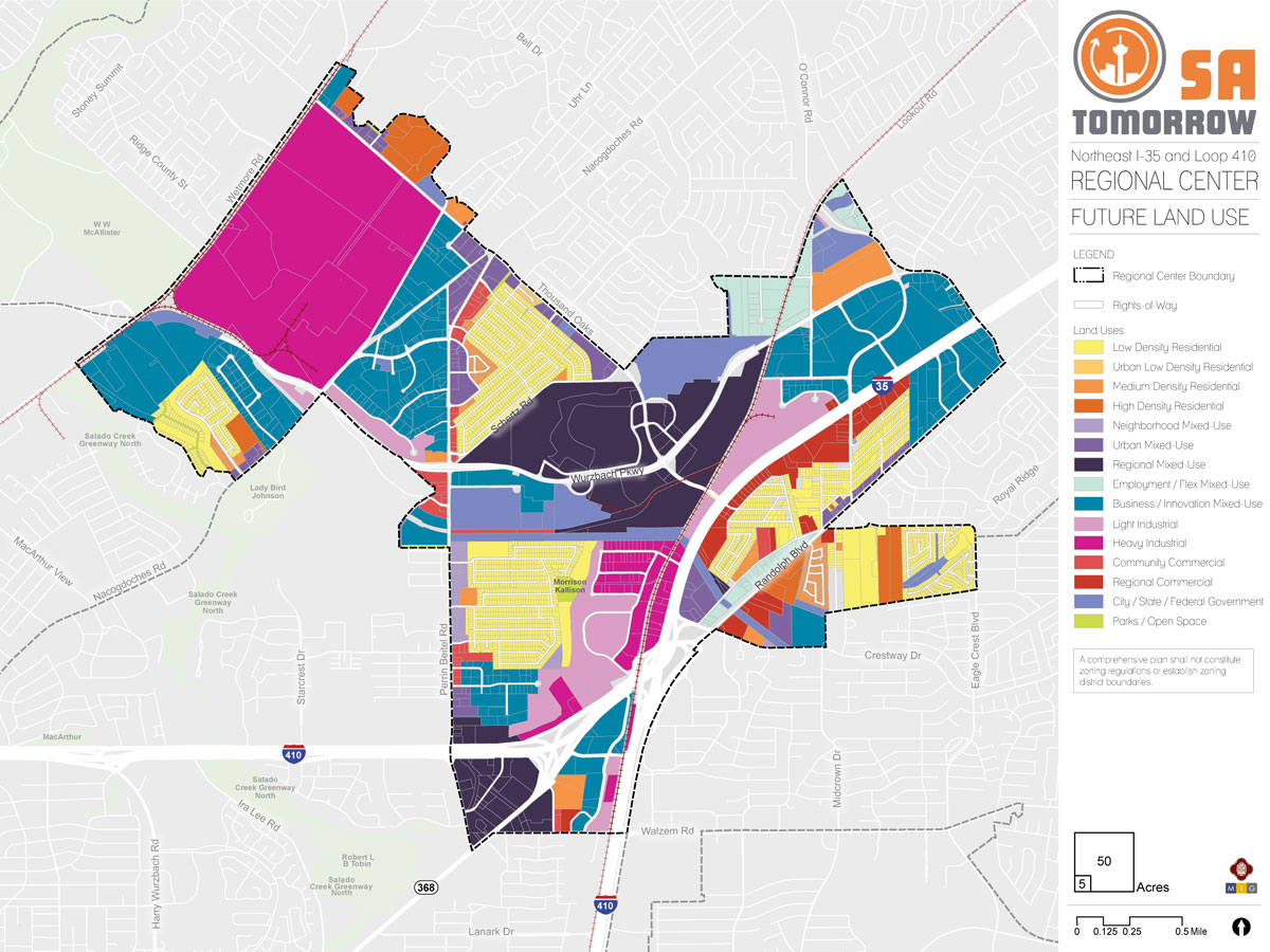
The NE I-35 and Loop 410 Area Regional Center Future Land Use Plan supports the SA Tomorrow Comprehensive Plan, Multimodal Transportation Plan, and Sustainability Plan, draws on recommendations from the SA Corridors Strategic Framework Plan and implements the Vision, Goals, and Plan Framework for the NE I-35 and Loop 410 Area. The Future Land Use Plan promotes neighborhood stability by encouraging growth and increased density at appropriate scales in mixed-use use centers and focus areas along key transit and community corridors.
The following sections describe the general future land use patterns of the Regional Center, provide recommendations for implementing the land use plan, and provide the full catalogue of land use categories (including descriptions and allowable zoning districts) adopted in the Unified Development Code Chapter 35 (UDC).
RESIDENTIAL AREAS
Residential areas include housing at varying levels of intensity from single-family detached homes to multi-family apartment buildings. Residents of existing single-family neighborhoods value the quiet and private green spaces their homes provide. Neighborhood areas are generally already well buffered from the more intense industrial uses located in the NE I-35 and Loop 410 Area Regional Center and the Future Land Use Plan will continue to encourage more intense land uses to congregate along the interstate, areas that offer geographic buffers, or in areas already established as intensely commercial. Relatively few areas in the Regional Center are designated for strictly medium or high density residential use. Rather, higher-density residential growth is encouraged in mixed-use areas and along mixed-use corridors. Neighborhood areas, classified as Urban Low Density Residential or Medium Density Residential on the future land use map, are supposed to be primarily quiet, stable residential places that retain their character in the future. The land use plan provides for a modest amount of additional households to join these neighborhoods, primarily where the existing zoning would support such growth. Commercial businesses should typically not encroach into these areas in so much as they cause significant disruption to the ambience and quality of life and divert commercial activity from places where it is specifically desired.
- Low Density Residential - Residential areas in the NE I-35 and Loop 410 Area Regional Center consist mostly of single-family detached housing located in both older, established neighborhoods such as Sungate, Hills of Park North, Oak Grove Estates, and Morningside Park/Pan Am and newer neighborhoods, such as Cheyenne Valley and Bristol Place. The Future Land Use Plan designates these areas as Low Density or Urban Low Density Residential in order to retain their character.
- Medium and High Density Residential - A handful of multi-family buildings are scattered along main thoroughfares such as Perrin Beitel Road, Thousand Oaks Drive, and Randolph Boulevard. New multi-family developments have recently been constructed, with more planned, in the Longhorn Quarry redevelopment area.
MIXED-USE CENTERS AND CORRIDORS
Mixed-use areas provide an integrated combination of residential, commercial, and institutional uses. The NE I-35 and Loop 410 Area Land Use Plan incorporates five mixed-use categories, each of which encourages a different mix of allowable uses, density, and intensity. Mixed-use areas can range in scale from small, neighborhood-serving development to intensely developed regional centers that are intended to serve a large geographic area. The NE I-35 and Loop 410 Area Future Land Use Plan encourages more dense and intense land uses in appropriate areas including mixed-use centers, designated focus areas, and along primary corridors. This supports development that best serves the needs of, and complements, surrounding areas. Mixed-use areas can support transitions between land use intensities, encourage economic development and revitalization, and provide communities with desired live, work, and play options.
- Neighborhood Mixed-Use - Neighborhood Mixed-Use areas contain a mix of residential and commercial uses at a neighborhood scale. These areas are intended to serve nearby neighborhoods while also helping to buffer them from more intense uses. Commercial areas along the NE I-35 and Loop 410 Area Regional Center’s major thoroughfares already provide service to surrounding neighborhoods, but there are a few locations where smaller-scale mixed-uses would be appropriate to transition to lower commercial intensity and buffer established neighborhoods. The locations appropriate for the Neighborhood Mixed-Use designation in the NE I-35 and Loop 410 Area are along the section of Perrin Beitel abutting the Sungate neighborhood, the southeast corner of the Sungate neighborhood, and a small area off of Crestway Drive.
- Urban Mixed-Use - Urban Mixed-Use areas contain a mix of residential, commercial, and institutional uses at a medium level of intensity. They are larger in scale than Neighborhood Mixed-Use areas and are intended to serve a larger geography. Within the NE I-35 and Loop 410 Area, Urban Mixed-Use areas are designated along Perrin Beitel Road, Thousand Oaks Drive, and Randolph Boulevard, at the intersection of Perrin Beitel Road, Thousand Oaks Drive and Nacogdoches Road, and the area just north of the VIA Randolph Park and Ride facility. The location of these areas along key corridors is intended to take advantage of VIA Metropolitan Transit (VIA) routes, encourage reinvestment, and provide more retail, service, entertainment, and living options for surrounding communities.
- Regional Mixed-Use - Regional Mixed-Use areas contain residential, commercial, and institutional uses at high densities. They are larger in scale than Urban Mixed-Use areas and are intended both to serve nearby communities and to be a draw for the surrounding region. There are two major areas designated as Regional Mixed-Use in the NE I-35 and Loop 410 Area: the Longhorn Quarry and the area located at the convergence of Loop 410, I-35, and the Austin Highway. Both areas have the potential to catalyze commercial and residential revitalization.
The Longhorn Quarry is currently under redevelopment and already contains a variety of recreational, entertainment, and medical uses. One multi-family residential community, the Upton, has been developed and more are planned. The Regional Mixed-Use designation allows the Longhorn Quarry to continue to evolve into an important regional destination.
The area at the convergence of Loop 410, I-35, and the Austin Highway is designated Regional Mixed-Use to take advantage of redevelopment already planned for the Santikos Rialto/Galaxy Theater. Several large underutilized and vacant properties with large parking lots surround the Santikos property and could be redeveloped to take advantage of the area’s proximity to major roads and one of VIA’s major transit corridors.
- Employment/Flex Mixed-Use - Employment/Flex Mixed-Use areas provide adaptable live/work environments with a mix of residential and light service industrial uses. This designation is appropriate for adaptive reuse of vacant or underutilized properties and is intended to support residential infill and employment opportunities for adjacent neighborhoods. There are two pockets of Employment/Flex Mixed-Use designated in the Regional Center: the area between Sherri Ann Road and Randolph Boulevard, and an area north of Wurzbach Parkway bisected by the railroad tracks.
- Business/Innovation Mixed-Use - Business/Innovation Mixed-Use areas provide a flexible, employment-focused live/work environment by accommodating residential, commercial, office, and light industrial uses within a cohesive setting. Several areas throughout the NE I-35 and Loop 410 Area Regional Center are designated as Business/Innovation Mixed-Use. This designation acknowledges that the NE I-35 and Loop 410 Area supports a wide variety of industrial and commercial uses ranging in intensity from warehousing to cement production and that its proximity to major highways is attractive to residents and employers. Business/Innovation Mixed-Use areas are intended to support the traditional industrial base of the Regional Center, allow adaptability with changing market preferences, and encourage cohesive large-scale development. The range of permitted zoning districts within the Business/Innovation Mixed-Use designation also facilitates appropriate transitions of intensity between land uses. Strategic and thoughtful transitioning of land use intensities is especially important in locations where Business/Innovation Mixed-Use areas abut places of established and ongoing industrial activity, such as the area surrounding the Capitol Aggregates facility on Bulverde Road.
COMMERCIAL AREAS
Commercial areas provide retail, professional service, and office uses at varying levels of intensity. There are relatively few areas of strictly commercial designation in the Regional Center. Where they exist, they are at medium and high levels of intensity.
- Community Commercial - Community Commercial uses are found primarily along Perrin Beitel Road. These lower intensity uses are intended to serve surrounding communities while also buffering them from more intense uses.
- Regional Commercial - More intense Regional Commercial uses are concentrated predominantly on the south side of I-35. These areas accommodate existing uses such as hotels and automobile sales, take advantage of highway access and visibility, and buffer the adjacent neighborhoods from the activity of I-35.
INDUSTRIAL AREAS
Industrial areas include manufacturing, fabrication, processing, and warehousing uses at varying levels of intensity. These areas are typically concentrated near arterials, expressways, and railroad lines. The NE I-35 and Loop 410 Area has traditionally had a strong industrial base with warehousing, rail shipments, quarrying, light manufacturing, and the production of cement products. The Future Land Use Plan encourages adjacent land uses to remain compatible with industrial activities to help preserve these employment uses in the area. Adjacent land uses should also serve as buffers to provide transitions to lower intensity mixed-use and residential areas.
- Light Industrial - The Future Land Use Plan accommodates areas of compatible light industrial activity between the railroad tracks and I-35, at major highway intersections, and in smaller pockets of business/flex space. Light industrial activities that are compatible with their surroundings are also permitted in the Business/Innovation Mixed-Use land use category.
- Heavy Industrial - The Capitol Aggregates facility, located between Bulverde and Wetmore Roads is the largest area of heavy industrial use in the Regional Center. The facility is projected to stay in operation for the long term. It is buffered by the Union Pacific railroad tracks, Wurzbach Parkway, and a berm on the Thousand Oaks Drive and Bulverde Road side. Smaller areas of heavy industrial uses are also located at the I-35 and Loop 410 intersection and along the railroad tracks south of the Longhorn Quarry. These areas are buffered from their surroundings by the railroad track, I-35, and areas of less intense industrial uses.
PARKS/OPEN SPACE
Parks/Open Space generally refers to large, linear, or unimproved land where conservation is promoted and development is not encouraged. The designation may include utility corridors and public or private land uses that encourage outdoor passive or active recreation. Examples include city owned and/or operated pocket, regional, or linear parks, as well as private parks associated with subdivisions and neighborhood associations.
The only Parks/Open Space designation in the NE I-35 and Loop 410 Area Regional Center is Kallison Park, a City-owned park, in the Sungate neighborhood. There are pockets of green space and unimproved land throughout the area, but these are in private ownership and have not been established as dedicated green or recreational space by deed or covenant. Because NE I-35 and Loop 410 Area communities have identified a desire for more green space, trails, and connectivity with adjacent parks and greenways, it is worth exploring the feasibility of using area utility easements to create these amenities.

Recommendation #1:
Support mixed-use redevelopment at a variety of scales in identified focus areas and along transit corridors.A wider variety of retail, service, and entertainment options have been identified as a priority for the NE I-35 and Loop 410 Area Regional Center. Although there is a limited amount of vacant land to support new development in the Regional Center, several areas could be suitable for mixed-use redevelopment or retrofit. Mixed-use redevelopment can create a range of opportunities – from regional destination attractions such as Toyota Field and Morgan’s Wonderland to retail and service businesses that serve the daily needs of the local community such as sit-down restaurants and shopping.
Large-scale mixed-use developments take advantage of proximity to expressways, major arterial roadways, and transportation hubs. The Longhorn Quarry and the “triangle” between the Loop 410/I-35, Perrin Beitel Road, Austin Highway, and Walzem Road intersection have been identified as focus areas for large-scale mixed-use redevelopment. Redevelopment of the Longhorn Quarry is currently underway and there are plans for a major renovation of the Rialto/Galaxy Theater located in the “triangle” intersection. By encouraging mixed-use redevelopment in this area, it is possible for the Rialto/Galaxy renovation to act as a catalyst for retrofits of adjacent underutilized and vacant buildings. Smaller scale-mixed use projects are appropriate for arterials that can support a local customer base and take advantage of VIA’s transit network. These smaller-scale focus areas are located along Perrin Beitel Road, Randolph Boulevard, Thousand Oaks Drive, and Naco Perrin Boulevard.
Recommendation #2:
Protect the character of established neighborhoods by locating higher-intensity land uses at major intersections, along transit corridors, and near established industrial areas.Strategically transitioning land use intensities acknowledges that residents in existing neighborhoods value the quiet and green space that their communities provide while also accommodating the growth necessary to support more community-serving businesses. Higher-intensity commercial and residential uses should be directed toward major arterials and areas already established for higher-intensity uses. The Future Land Use Plan supports the NE I-35 and Loop 410 Area Regional Center’s existing industrial uses while also allowing for appropriate transition of these areas into less intense commercial and residential uses over time.
Recommendation #3:
Promote transit-supportive land use (TSLU) near existing and planned transit station areas and key transit corridors.Transit supportive land use (TSLU) provides residents and workers a range of mobility choices, access to daily needs, commercial services, and recreational opportunities, as well as key destinations like work and school, within a short distance from home. TSLU allows for more efficient use of land and can help communities develop in a way that limits conflicts between vehicles, pedestrians, and transit operations. VIA Metropolitan Transit published a Guide to Transit Supportive Land Use in 2014 that provides resources and guidance for the development of transit supportive places. Within the NE I-35 and Loop 410 Area, transit supportive land use takes the form of appropriately-scaled mixed-use areas in close proximity to VIA bus routes, the Naco Pass Transfer Station, and the Randolph Park and Ride.
Recommendation #4:
Preserve the long-standing employment base of the Regional Center with land use designations that support existing industrial uses, while also providing opportunities for new and emerging industries.Industrial uses, such as warehousing, distribution, and construction, create the largest number of jobs in the Regional Center. The Future Land Use Plan supports these employment-generating uses while also acknowledging that, over time, market demands can change. Flexible land uses can help transitioning industrial areas remain competitive as the economy and markets change.
Recommendation #5:
Encourage Low-Impact Development (LID) and the use of floodplain land for parks, greenbelts, and open spaces where appropriate.
Low-Impact Development (LID) is an approach to development that works with nature to manage stormwater by preserving and recreating natural landscape features and minimizing impervious surfaces. Due to the amount of floodplain land in the NE I-35 and Loop 410 Area Regional Center, integrated stormwater management planning should be implemented in this area. The use of floodplains as community amenities – parks, trails, and recreational areas – is also encouraged where feasible and appropriate.
Future Land Use Categories
As described above, the NE I-35 and Loop 410 Area Regional Center Plan includes a range of land use designations that represent the unique character of the area, while encouraging and supporting development patterns that reflect the goals of the SA Tomorrow Comprehensive Plan and the preferences of the NE I-35 and Loop 410 area community. Listed below is the full list of land use categories adopted by City Council into the Unified Development Code (UDC), Chapter 35, on October 11, 2018. Each category listed includes a description, general guidance on where the land use designation is most appropriate, and a list of allowable zoning districts.
Residential Estate
Includes large lot single-family detached houses on individual estate-sized lots or in conservation subdivisions. This form of development should be located away from major arterials, and can include certain nonresidential uses such as schools, places of worship, and parks that are centrally located for convenient neighborhood access. Permitted zoning districts: FR, R-20, RE, and RP.
- Typical densities in this land use category would be up to 2 dwelling units per acre.
Low Density Residential
Regional Mixed-Use

- IDZ, PUD, MXD, TOD and MPCD may be considered consistent with this land use category, provided the permitted uses included on the zoning site plan and zoning ordinance are consistent with the uses and densities outlined above.
Employment/Flex Mixed-Use
.jpg)
- IDZ, PUD, MXD, TOD and MPCD may be considered consistent with this land use category, provided the permitted uses included on the zoning site plan and zoning ordinance are consistent with the uses and densities outlined above.
Business/Innovation Mixed-Use
Accommodates industrial uses with office, commercial, and residential uses, all within a cohesive setting, on a larger scale and within larger footprints than the Employment/Flex Mixed-Use category. Industrial arts workshops, high tech fabrication, processing and assembly, and other industrial uses are permitted, in addition to commercial uses. Vocational training, technological learning centers, medical campuses, and research/development institutions are also appropriate for these spaces. Additional environmental performance standards should be employed for properties designated as Business/Innovation Mixed-Use, such as hours of activity, loading, noise levels and lighting, to ensure that the intensity of the industrially oriented uses is comparable to that of the other non-residential uses. The mix of uses may be either vertically or horizontally distributed. Live/work housing options are permissible in Business/Innovation Mixed Use areas to ensure access to housing options and services within close proximity of business innovation areas for the local-workforce. Business/Innovation mixed use should incorporate transit and bicycle facilities to serve the training and employment base. Permitted zoning districts: RM-4, MF-18, MF-25, O-1.5, O-2, C-2, C-3, L, I-1, MI-1, BP, AE-1, AE-2, AE-3, and AE-4.
- IDZ, PUD, MXD, TOD and MPCD may be considered consistent with this land use category, provided the permitted uses included on the zoning site plan and zoning ordinance are consistent with the uses and densities outlined above.
Light Industrial
Includes a mix of manufacturing uses, business park, and limited retail/service uses that serve the industrial uses. Industrial uses should be screened and buffered from adjoining non-industrial uses. Any outside storage should be under a roof and screened from public view. Examples of light industrial uses include drug laboratories, furniture wholesalers, lumberyards, food production, and warehousing. Permitted zoning districts: L, I-1, MI-1, and BP.
- IDZ, TOD, and MPCD may be considered consistent with this land use category, provided the permitted uses included on the zoning site plan and zoning ordinance are consistent with the uses and densities outlined above.
Heavy Industrial
Includes heavy manufacturing, processing and fabricating businesses. Heavy industrial uses shall be concentrated at arterials, expressways, and railroad lines. This category is not compatible with neighborhood-scaled categories or those that permit residential zoning. Heavy Industrial should be separated from non-industrial uses by an allowable land use or a significant buffer. Examples of heavy industrial uses include auto manufacturing, battery manufacturing, and petro chemical bulk storage. Permitted zoning districts: I-1, I-2, MI-1, MI-2, QD, and SGD.
Agricultural
Includes crop agriculture, ranching, and related agribusiness practices. Single-family detached houses and detached accessory dwelling units are permitted on agricultural and ranch lands at very low densities or in conservation subdivisions that will not interfere with agricultural operations. Limited commercial uses directly serving agricultural and ranching uses, such as farmers markets, nurseries, stables, bed and breakfasts are permitted. To maintain scenic qualities, natural vegetative buffers, deeper setbacks, increased signage control, earthen drainage channels, and more restrictive access management standards are desired along major scenic corridors. Floodplain protection and buffer zones along creeks and rivers are instrumental in retaining rural character. Permitted zoning districts: RP and FR.
Parks/Open Space
May include, but is not limited to, large, linear, or unimproved land where conservation is promoted and development is not encouraged due to the presence of topographic constraints or institutional uses on the site. Parks/Open Space may include utility corridors and public or private land uses that encourage outdoor passive or active recreation. Examples include city owned and/or operated pocket, regional, or linear parks, as well as private parks associated with subdivisions and neighborhood associations.
City/State/Federal Government
Includes areas owned and operated by a federal, state, or city agency. Examples may include government offices, public service facilities such as libraries and police stations, military bases, state colleges, and federal courts. This category does not apply to properties owned by a public agency but leased to and operated by another party.
The NE I-35 and Loop 410 Area Regional Center Future Land Use Plan supports the SA Tomorrow Comprehensive Plan, Multimodal Transportation Plan, and Sustainability Plan, draws on recommendations from the SA Corridors Strategic Framework Plan and implements the Vision, Goals, and Plan Framework for the NE I-35 and Loop 410 Area. The Future Land Use Plan promotes neighborhood stability by encouraging growth and increased density at appropriate scales in mixed-use use centers and focus areas along key transit and community corridors.
The following sections describe the general future land use patterns of the Regional Center, provide recommendations for implementing the land use plan, and provide the full catalogue of land use categories (including descriptions and allowable zoning districts) adopted in the Unified Development Code Chapter 35 (UDC).
RESIDENTIAL AREAS
Residential areas include housing at varying levels of intensity from single-family detached homes to multi-family apartment buildings. Residents of existing single-family neighborhoods value the quiet and private green spaces their homes provide. Neighborhood areas are generally already well buffered from the more intense industrial uses located in the NE I-35 and Loop 410 Area Regional Center and the Future Land Use Plan will continue to encourage more intense land uses to congregate along the interstate, areas that offer geographic buffers, or in areas already established as intensely commercial. Relatively few areas in the Regional Center are designated for strictly medium or high density residential use. Rather, higher-density residential growth is encouraged in mixed-use areas and along mixed-use corridors. Neighborhood areas, classified as Urban Low Density Residential or Medium Density Residential on the future land use map, are supposed to be primarily quiet, stable residential places that retain their character in the future. The land use plan provides for a modest amount of additional households to join these neighborhoods, primarily where the existing zoning would support such growth. Commercial businesses should typically not encroach into these areas in so much as they cause significant disruption to the ambience and quality of life and divert commercial activity from places where it is specifically desired.
- Low Density Residential - Residential areas in the NE I-35 and Loop 410 Area Regional Center consist mostly of single-family detached housing located in both older, established neighborhoods such as Sungate, Hills of Park North, Oak Grove Estates, and Morningside Park/Pan Am and newer neighborhoods, such as Cheyenne Valley and Bristol Place. The Future Land Use Plan designates these areas as Low Density or Urban Low Density Residential in order to retain their character.
- Medium and High Density Residential - A handful of multi-family buildings are scattered along main thoroughfares such as Perrin Beitel Road, Thousand Oaks Drive, and Randolph Boulevard. New multi-family developments have recently been constructed, with more planned, in the Longhorn Quarry redevelopment area.
MIXED-USE CENTERS AND CORRIDORS
Mixed-use areas provide an integrated combination of residential, commercial, and institutional uses. The NE I-35 and Loop 410 Area Land Use Plan incorporates five mixed-use categories, each of which encourages a different mix of allowable uses, density, and intensity. Mixed-use areas can range in scale from small, neighborhood-serving development to intensely developed regional centers that are intended to serve a large geographic area. The NE I-35 and Loop 410 Area Future Land Use Plan encourages more dense and intense land uses in appropriate areas including mixed-use centers, designated focus areas, and along primary corridors. This supports development that best serves the needs of, and complements, surrounding areas. Mixed-use areas can support transitions between land use intensities, encourage economic development and revitalization, and provide communities with desired live, work, and play options.
- Neighborhood Mixed-Use - Neighborhood Mixed-Use areas contain a mix of residential and commercial uses at a neighborhood scale. These areas are intended to serve nearby neighborhoods while also helping to buffer them from more intense uses. Commercial areas along the NE I-35 and Loop 410 Area Regional Center’s major thoroughfares already provide service to surrounding neighborhoods, but there are a few locations where smaller-scale mixed-uses would be appropriate to transition to lower commercial intensity and buffer established neighborhoods. The locations appropriate for the Neighborhood Mixed-Use designation in the NE I-35 and Loop 410 Area are along the section of Perrin Beitel abutting the Sungate neighborhood, the southeast corner of the Sungate neighborhood, and a small area off of Crestway Drive.
- Urban Mixed-Use - Urban Mixed-Use areas contain a mix of residential, commercial, and institutional uses at a medium level of intensity. They are larger in scale than Neighborhood Mixed-Use areas and are intended to serve a larger geography. Within the NE I-35 and Loop 410 Area, Urban Mixed-Use areas are designated along Perrin Beitel Road, Thousand Oaks Drive, and Randolph Boulevard, at the intersection of Perrin Beitel Road, Thousand Oaks Drive and Nacogdoches Road, and the area just north of the VIA Randolph Park and Ride facility. The location of these areas along key corridors is intended to take advantage of VIA Metropolitan Transit (VIA) routes, encourage reinvestment, and provide more retail, service, entertainment, and living options for surrounding communities.
- Regional Mixed-Use - Regional Mixed-Use areas contain residential, commercial, and institutional uses at high densities. They are larger in scale than Urban Mixed-Use areas and are intended both to serve nearby communities and to be a draw for the surrounding region. There are two major areas designated as Regional Mixed-Use in the NE I-35 and Loop 410 Area: the Longhorn Quarry and the area located at the convergence of Loop 410, I-35, and the Austin Highway. Both areas have the potential to catalyze commercial and residential revitalization.
The Longhorn Quarry is currently under redevelopment and already contains a variety of recreational, entertainment, and medical uses. One multi-family residential community, the Upton, has been developed and more are planned. The Regional Mixed-Use designation allows the Longhorn Quarry to continue to evolve into an important regional destination.
The area at the convergence of Loop 410, I-35, and the Austin Highway is designated Regional Mixed-Use to take advantage of redevelopment already planned for the Santikos Rialto/Galaxy Theater. Several large underutilized and vacant properties with large parking lots surround the Santikos property and could be redeveloped to take advantage of the area’s proximity to major roads and one of VIA’s major transit corridors.
- Employment/Flex Mixed-Use - Employment/Flex Mixed-Use areas provide adaptable live/work environments with a mix of residential and light service industrial uses. This designation is appropriate for adaptive reuse of vacant or underutilized properties and is intended to support residential infill and employment opportunities for adjacent neighborhoods. There are two pockets of Employment/Flex Mixed-Use designated in the Regional Center: the area between Sherri Ann Road and Randolph Boulevard, and an area north of Wurzbach Parkway bisected by the railroad tracks.
- Business/Innovation Mixed-Use - Business/Innovation Mixed-Use areas provide a flexible, employment-focused live/work environment by accommodating residential, commercial, office, and light industrial uses within a cohesive setting. Several areas throughout the NE I-35 and Loop 410 Area Regional Center are designated as Business/Innovation Mixed-Use. This designation acknowledges that the NE I-35 and Loop 410 Area supports a wide variety of industrial and commercial uses ranging in intensity from warehousing to cement production and that its proximity to major highways is attractive to residents and employers. Business/Innovation Mixed-Use areas are intended to support the traditional industrial base of the Regional Center, allow adaptability with changing market preferences, and encourage cohesive large-scale development. The range of permitted zoning districts within the Business/Innovation Mixed-Use designation also facilitates appropriate transitions of intensity between land uses. Strategic and thoughtful transitioning of land use intensities is especially important in locations where Business/Innovation Mixed-Use areas abut places of established and ongoing industrial activity, such as the area surrounding the Capitol Aggregates facility on Bulverde Road.
COMMERCIAL AREAS
Commercial areas provide retail, professional service, and office uses at varying levels of intensity. There are relatively few areas of strictly commercial designation in the Regional Center. Where they exist, they are at medium and high levels of intensity.
- Community Commercial - Community Commercial uses are found primarily along Perrin Beitel Road. These lower intensity uses are intended to serve surrounding communities while also buffering them from more intense uses.
- Regional Commercial - More intense Regional Commercial uses are concentrated predominantly on the south side of I-35. These areas accommodate existing uses such as hotels and automobile sales, take advantage of highway access and visibility, and buffer the adjacent neighborhoods from the activity of I-35.
INDUSTRIAL AREAS
Industrial areas include manufacturing, fabrication, processing, and warehousing uses at varying levels of intensity. These areas are typically concentrated near arterials, expressways, and railroad lines. The NE I-35 and Loop 410 Area has traditionally had a strong industrial base with warehousing, rail shipments, quarrying, light manufacturing, and the production of cement products. The Future Land Use Plan encourages adjacent land uses to remain compatible with industrial activities to help preserve these employment uses in the area. Adjacent land uses should also serve as buffers to provide transitions to lower intensity mixed-use and residential areas.
- Light Industrial - The Future Land Use Plan accommodates areas of compatible light industrial activity between the railroad tracks and I-35, at major highway intersections, and in smaller pockets of business/flex space. Light industrial activities that are compatible with their surroundings are also permitted in the Business/Innovation Mixed-Use land use category.
- Heavy Industrial - The Capitol Aggregates facility, located between Bulverde and Wetmore Roads is the largest area of heavy industrial use in the Regional Center. The facility is projected to stay in operation for the long term. It is buffered by the Union Pacific railroad tracks, Wurzbach Parkway, and a berm on the Thousand Oaks Drive and Bulverde Road side. Smaller areas of heavy industrial uses are also located at the I-35 and Loop 410 intersection and along the railroad tracks south of the Longhorn Quarry. These areas are buffered from their surroundings by the railroad track, I-35, and areas of less intense industrial uses.
PARKS/OPEN SPACE
Parks/Open Space generally refers to large, linear, or unimproved land where conservation is promoted and development is not encouraged. The designation may include utility corridors and public or private land uses that encourage outdoor passive or active recreation. Examples include city owned and/or operated pocket, regional, or linear parks, as well as private parks associated with subdivisions and neighborhood associations.
The only Parks/Open Space designation in the NE I-35 and Loop 410 Area Regional Center is Kallison Park, a City-owned park, in the Sungate neighborhood. There are pockets of green space and unimproved land throughout the area, but these are in private ownership and have not been established as dedicated green or recreational space by deed or covenant. Because NE I-35 and Loop 410 Area communities have identified a desire for more green space, trails, and connectivity with adjacent parks and greenways, it is worth exploring the feasibility of using area utility easements to create these amenities.