Plan Framework
Mobility
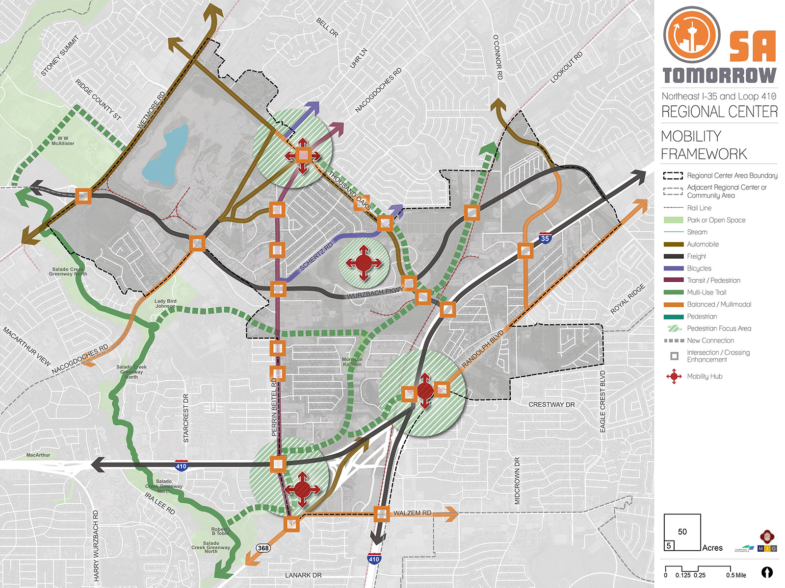
The map below highlights the Mobility Framework identified for the NE I-35 and Loop 410 Regional Center Area. Scroll down to learn more about the vision for Mobility in the Plan Area.
To provide specific feedback on the map, please click and drag a box on that location of the map and fill out the comment box. We would love to hear more from you!
You can also visit the bottom of the page to leave additional feedback.
Background and Vision
In 2016 the City of San Antonio adopted the SA Tomorrow Multimodal Transportation Plan, to make our city’s transportation system “sustainable, safe, convenient, efficient, and inclusive of all modes.” The plan adopted by City Council established “a shift in focus from moving vehicles to moving people,” in order to manage traffic congestion and improve transportation choices. The plan identified two primary and interdependent methods for managing future traffic congestion:
- Develop a land use pattern and policy to promote local trips
- Provide transportation options in addition to vehicles that connect Regional Centers
SA Tomorrow Multimodal Transportation Plan acknowledged that we cannot build our way out of congestion, and that the SA Tomorrow Comprehensive Plan, and associated Sub-Area land use plans, are a primary opportunity to improve mobility in San Antonio. By welcoming more people to live, work, and play in urban centers, regional centers, and transit corridors, we can shorten trip lengths, offer more transportation choices, and improve quality of life.
The combined costs of housing and transportation (commonly referred to as H+T) are often a large portion of a household’s budget, with experts recommending the combined total not be more than 45% of household income. In the Greater San Antonio Region that total on average is 53%. Walkable communities that provide great transit options can reduce the household transportation costs for the average person. If people have an alternative to driving alone, transportation costs can be stable even when gas prices rise. Multiple transportation options allow people to choose other forms of mobility, such as walking, bicycling, or transit. This helps reduce the number of cars on the road and alleviate traffic delays for those who chose to drive.
As its name implies, the NE I-35 and Loop 410 Area Regional Center includes two primary interstates both serving as vital arteries connecting San Antonio's major centers of employment. This major highway exchange is also critical to the movement of freight and facilitating both domestic and international trade. Supporting a wide range of major destinations, including Morgan's Wonderland, Heroes Stadium, Toyota Field, the Salado Creek Greenway, and industrial parks, the transportation network of the Regional Center accommodates a wide range of transportation demand.
As the NE I-35 and Loop 410 area continues to grow, mobility enhancements will emphasize increasing vehicle efficiency along freeways and arterial roadways while ensuring connectivity and ease of movement of people along collector and local roadways. Transportation projects, including the I-35 Northeast Expansion Project (NEX) and the reconfiguration of Weidner Road and Randolph Boulevard, are planned to address some the Regional Center's mobility challenges. By adding additional transit priority treatments, improving the sidewalk network, and relieving congestion on major roadways, this area will improve the efficiency of its existing multimodal transportation network. The continued focus on the relationship between street networks and community character will serve as an economic catalyst to accommodate the Regional Center's growth.
NE I-35 and Loop 410 Area Regional Center's Mobility Needs
Investments in transportation improvements are continuously made to move large volumes of freight efficiently, link neighborhood development to growing employment opportunities, and provide adequate transit routes that connect to regions outside of the of the NE I-35 and Loop 410 area. Growing populations demand that streets not only carry people, goods, and services, but also serve as playgrounds, parks, and public spaces. Key mobility needs indentified in this Regional Center include the following:
- Improved walking, transit, and safety facilities;
- Connections between scattered employment and commerical offerings;
- Support for transit as an economic catalyst (including VIA Link mobility on-demand program and future phases VIA Advanced Rapid Transit); and
- Identification of opportunities to connect to the reginoal greenway system (potentially using utility easements off Perrin Beitel Road and drainage easements in the southern portion of the plan area).
To address the transportation needs of the NE I-35 and Loop 410 Regional Center, a set of high-level street classification recommendations have been developed to guide decision-making. Recommendations include modal and intersection priorities, shown in the Mobility Framework Map [FIGURE-1]. Street type and use recommendations are shown in the Proposed Street Types Map [FIGURE-2]. These mobility recommendations will be further refined in a coordinated manner with the City's Public Works Department and other relevant partners such as Texas Department of Transportation (TXDOT), VIA Metropolitan Transit (VIA), and the Alamo Area Metropolitan Planning Organization (AAMPO).
NE I-35 and Loop 410 Area Regional Center Mobility Framework
The Mobility Framework lays out the vision for accommodating the constantly expanding mobility needs of the NE I-35 and Loop 410 Area Regional Center. Described below are the principles used to create a mobility network that is safe, efficient, and affordable for all users including pedestrians, bicyclists, motorists, and transit riders. The Mobility Framework Map [FIGURE-1] illustrates each of the elements of the mobility network described in the section below.
Modal Priority Corridors
Streets play a multifaceted role in the plan area, serving as arteries for traffic and as public spaces. Changes to street design can help to achieve the community's overarching vision for the Regional Center. The modal priority corridors reflect the vision of how motorists, bicyclists, transit users, and pedestrians will interact with the corridor. Modal priority corridors guide design treatments of a particular mode. A modal priority corridor does not exclude other users but helps guide tradeoff decisions during the design of a specific street.
Automobile - Automobile corridors are envisioned to support high levels of motor vehicle travel daily. These corridors are often interstates, highways, and arterial and primary roadways which provide connections to major destinations and link the Regional Center to the other areas. Significant automobile corridors in the NE I-35 and Loop 410 area include, but are not limited to, O'Conner Road, Thousand Oaks Drive, Bulverde Road, and Wetmore Road. Automobile corridor improvements can relieve traffic congestion and enhance roadway design to increase the safety of motor vehicle travel.
Freight - Freight corridors are envisioned to support the movement of high volumes of goods by freight trucks that will travel between industrial or commercial areas and major destinations. Priority freight corridors - including NE Loop 410, I-35, and Wurzbach Parkway - all support the movement of significant volumes of goods and commodities throughout the region.
Bicycles - Bicycle corridors are envisioned to faciliate biking as a convenient, safe, and comfortable option for all ages and abilities. In addition to transportation functions, bicycle networks also provide recreational opportunities. An integrated network of bicycle routes along with well-designed streets in key activity areas aims to fill the gaps in the multi-modal system. The mobility framework focuses on completing the bicycle network and recommends new connections to directly access trails and other amenities. Schertz Road in the Hills of Park North neighborhood and Uhr Lane are identified as priority bicycle corridors in the NE I-35 and Loop 410 plan area.
Transit/Pedestrian - Transit and pedestrian corridors are envisioned to provide the community with easy, reliable, and congestion-proof choices for traveling to and from work, school, and key destinations. Streets, intersections, and traffic signals greatly influence transit service reliability and the passenger's transit experience. Providing streets that enable reliable and frequent transit service and a walkable environment allows users to choose travel options besides driving - alleviating a primary cause of congestion. Dedicated transit lanes, signal timing, and operational improvements can keep transit vehicles moving regardless of traffic. The priority transit/pedestrian corridor in the NE I-35 and Loop 410 area includes Perrin Beitel Road from Austin Highway to its connection at Nacogdoches Road.
Multi-Use Trail - Multi-use trail corridors are envisioned to provide continuous arteries of separated pedestrian and bicycle facilities that connect numerous destinations, parks, retail and commercial development, schools libraries, and residential areas. A multi-use trail provides access points to regional amenities and improves connections for people walking, strolling, or bicycling. The NE I-35 and Loop 410 area currently includes the Salado Creek Greenway North, with planned extensions to Kallison Park, Heroes Stadium, Toyota Field, and McAllister Park. The extension of the greenway will privide an easy travel option for people walking, cycling, or strolling to numerous attractions and open spaces.
Balanced/Multimodal - Balanced multimodal corridors are envisioned as "complete streets." Complete streets are designed to enable safe access for all users including pedestrians, bicyclists, motorists, and transit riders of all ages and abilities. These corridors balance the priorities of multiple modes and require continual community conversations and case-by-case design to best align with community vision. The function of the road, level of traffic by mode, and adjacent land use and intensity will help to determine the road type and design features. The NE I-35 and Loop 410 area has multiple priority locations for multimodal investments, including Nacogdoches Road south of Wurzbach Parkway, Walzem Road, Randolph Boulevard, Thousand Oaks Drive near the proposed mobility hub at the Nacogdoches Raod and Perrin Beitel intersection, and Crosswinds Way.
Pedestrian Focus Areas
Pedestrian focus areas refer to specific nodes that accommodate significant volumes of pedestrian activity. These focus areas aim to create high-quality street-level experiences to enhance the economic strength of commercial and mixed-use districts. These areas include wide sidewalks, safe intersections, ample crossing opportunities, and design characteristics focused on keeping pedestrians safe. Pedestrian focus areas have been identified near the regional mixed-use activity center near Loop 410 and Perrin Beitel Road, near the VIA Randolph Park and Ride, near the Longhorn Quarry redevelopment, and the activity node located on Thousand Oaks Drive at its intersection with Perrin Beitel and Nacogdoches Roads. All four areas have been identified as major destinations for the NE I-35 and Loop 410 Area Regional Center and provide easy access to restaurants, shops, and other community amenities.
Intersection/Crossing Enhancements
Intersection and crossing enhancements, whether signalized or unsignalized, are envisioned as intuitive and predictable crossings for all users. Enhancement locations are identified as areas where crossing is considered a priority and pedestrians, motorists, and bicyclists share space. Intersection enhancements include lowering motor vehicle travel speeds and ensuring high pedestrian visibility. Priority intersection and crossing enhancement locations are identified where complex movements occur and potential conflicts between pedestrians, bicyclists and drivers exist. Almost every major intersection in the Regional Center could benefit from enhanced crossings, including, but not limited to, Perrin Beitel Road, Walzem Road, Randolph Boulevard, and Thousand Oaks Drive. There is also a need for enhanced crossings under highway overpasses such as Crosswinds Way under I-35 and Nacogdoches and Wetmore Roads under Wurzbach Parkway.
Mobility Hubs
Mobility hubs are envisioned as scalable nodes of mobility options such as frequent transit, shared rides, bicycling, and micro-mobility. These nodes combine multimodal access and connectivity with adequate lighting, shelters, benches, real-time information, accessible sidewalks, and pedestrian crossings. Four mobility hub locations have been identified for the Regional Center. They include the mixed-use activity center near Perrin Beitel Road and Walzem Road, the VIA Randolph Park and Ride facility, near the Longhorn Quarry, and the activity node on Thousand Oaks Drive and Nacogdoches Road.
NE I-35 and Loop 410 Area Regional Center Street Types
As communities evolve and grow, so do the demands on the mobility system. The location and type of growth in an area or along a corridor help determine the demand on the transportation network and the viability of various transportation options. This interdependence makes it crucial to plan for transportation and land use collectively. Streets are organized not only by role and function, but also by the surrounding area's character and context.
Land uses encouraging mixed-use and higher density developments on major roadways will lead to additional pedestrians, bicyclists, transit riders, cars, and freight delivery trucks of various sizes. A future land use plan also influences other factors, such as drop-off and delivery zones, shared mobility hubs, and walkability. The Proposed Street Types Map [FIGURE-2] shows the interactions between future land use and transportation plans. The street type classifications integrate transportation and land use to guide context-sensitive mobility solutions.
Creating Street Types
To conceptualize the types of streets needed to align with the Regional Center's future land use designations, several "Street Types" were created by intersecting roadway "Functional Classifications" with surrounding "Land Use Context." Functional classifications are categories used in the City of San Antonio Major Thoroughfare Plan and Map to describe how streets are used in terms of intensity of vehicular traffic. For example, a roadway with a functional classification of Super Arterial has the primary job of moving cars quickly between farther destinations, while a roadway with a Local/Other classification features slower vehicle speeds and lighter traffic with a more pedestrian-friendly environment. Land use context refers to the character and types of land uses surrounding the roadway. For the purposes of creating Street Types, the Regional Center's future land use designations were used.
[FIGURE-3] is a matrix illustrating how functional street classifications were merged with land use context to create street types. In this matrix, "Functional Street Classifications" are shown in the left column and "Land Use Contexts" are shown in the top row. The cells of the matrix show the "Street Types," which are shaded in gradients of blue - with a lighter blue signifying a priority for moving vehicles and a darker blue signaling a focus on people and places. For example, a Local/Other road in a Mixed-Use context would be very walkable and allow people to walk or bike between shops and residences. Conversely, some roads are necessary for moving vehicles and freight, which could be examples of Super Arterials, Primary Arterials, or Rural roads in Suburban Commerical, Industrial, or Mixed-Use areas.
Not all streets can be fully for cars because the future for San Antonio is more walkable and includes more transportation options. Not all streets can be fully for pedestrians because there is still a need to move goods, provide fast and efficient transit, and to accommodate people traveling longer distances. The Street Types exercise helps us to determine which streets should be prioritized for changes to make them consistent with the Regional Center future land use map and contribute to the larger vision for the Regional Center and City overall.
[Placeholder for Figure-3: Street Types: Functional Classification and Land Use Context Matrix]
Street Types in the NE I-35 and Loop 410 Area Regional Center
The combination of Functional Street Classification and Land Use Context created a menu of Street Types that could be applied to the NE I-35 and Loop 410 Area Regional Center. The Proposed Street Types Map [FIGURE-2] illustrates how Functional Street Classifications intersect with Land Use Context to create composite Street Types for the Regional Center. In the map legend, Functional Classifications are symbolized with lines in various patterns (e.g. dots or dashes) and Land Use Context is symbolized with solid lines in various colors. On the map, Street Types are illustrated as a combination of patterned lines in various colors; major roads in the Regional Center have each been coded with a Street Type.
The major highways of the NE I-35 and Loop 410 area are classified as major freeways - rapidly moving goods and traffic with major commercial uses on either side of the highway. Wurzbach Parkway divides the Regional Center into northern and southern halves. This roadway transitions from an Industrial Super Arterial to Mixed-Use Employment/Civic use as it moves from east to west towards the I-35 intersection.
Portions of Thousand Oaks Drive and Perrin Beitel Road are classified as Secondary Arterials in a Mixed-Use Residential/Storefront context. These streets still need to move goods and traffic as they are some of the main roadways of the Regional Center, but in the future, the surrounding context of these roads is envisioned to become more Mixed-Use with a residential and retail focus. To better support residents and businesses, these roads should balance multiple modes of travel such as sidewalks, trails, and mass transit.
Other sections of Thousand Oaks Drive and Perrin Beitel Road are envisioned to become Secondary Arterials in a more Mixed-Use Employment/Civic context. These roadways still need to move goods, but can also serve employees who work in the area. There might be less surrounding residential and retail uses, but those employed in the area could benefit from sidewalks, transit, and bicycle infrastructure to better access other parts of the Regional Center.
[Figure-2: Proposed Street Types]
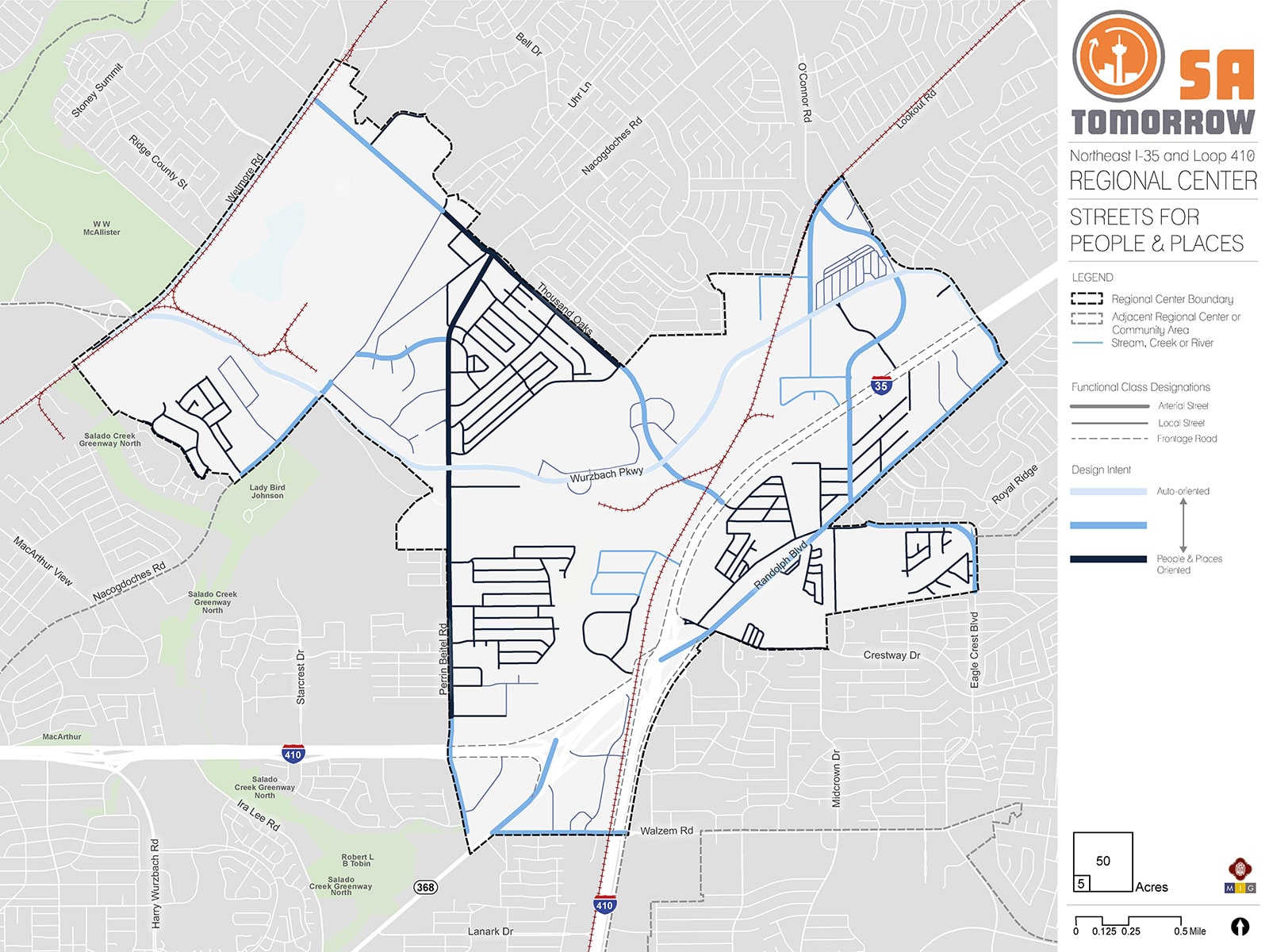
Another way to illustrate the Proposed Street Types Map is illustrated in [Figure-2] Street Types Map: Streets for People and Places. This map shows the Regional Center’s streets classified into the same gradient of intensity between car-focused and people/places-focused. As shown on the map, most of the roadways in the Regional Center should have a more people- and places-focused approach going forward to support the future land use vision. Major thoroughfares will still be needed, but some of the smaller roads supporting a more mixed-use context should have more modes of travel available to residents and employees.
[Figure-4: Streets for People and Places]
Relationship Between the Street and Buildings
Safe and vibrant streetscapes depend on how buildings integrate with surrounding sidewalks. Minimizing building setbacks, the distance between a building and the street, is key for creating a walkable environment. When buildings directly meet the sidewalk, as opposed to a parking lot, they create a more personal, inviting connection with passersby. This creates an enlivened urban space with opportunities to activate ground-floor uses and provide shopping or entertainment offerings.
Smaller setbacks are characteristic of Mixed-Use Local, or Urban/Suburban Local street types, which prioritize pedestrian-oriented design. Meanwhile, larger setbacks that can accommodate front-end parking, are more characteristic of secondary arterials (whether suburban, industrial, mixed-use, or urban). Primary arterials are designed to move vehicles and may require large setback minimums to accommodate additional parking.
Vehicle Speeds
A successful street hierarchy will align travel speeds with street usages. It will increase or decrease speed according to roadway function and the surrounding land use context. While major regional roads may require higher speeds to accommodate heavy traffic flows, most smaller roadways serve lower volumes of vehicles. On these roads, lower speeds ensure a safe environment for vehicles and people alike.
Street types that focus on moving vehicles, such as Suburban Commercial, Residential, or Industrial Super and Primary Arterials, will feature higher speeds. However, street types that focus on people and places, such as Mixed-use, Multi-Family, Urban/Suburban Local Roads, and Secondary Arterials, will feature lower speed limits, to increase road safety for both people and vehicles.
Parking
Parking provides access to work, retail, or entertainment. Cars searching for parking can create serious traffic and safety challenges. Incorporating safe street design elements, such as buffering between bike lanes and traffic, can create a safer on-street parking environment.
Street types that emphasize people and places, such as those with Mixed-use or Multi-family contexts, will restrict the supply of parking overall. Restricting space allocated for parking allows for more active uses, denser environments, and connectivity for pedestrians and cyclists. Meanwhile, intermediary street types that support vehicles as well as people and places will likely offer some on-street parking, in addition to smaller on-site lots. Conversely, Suburban Contexts or Super and Primary Arterials may forgo on-street parking altogether, favoring large surface lots and structures.
Curb Access
A space between the curb and the travel lanes provides an opportunity to serve many uses such as driveways, bus lanes, cycle tracks, on-street parking, bicycle parking, freight drop-off delivery zones, or shared mobility hubs. This flexible zone can be converted based on demand and play a role in street activation. The design of the curb influences how cars and people enter and exit work, residential, and retail environments. Addressing areas where traffic and turning patterns increase the risk of accidents will reduce conflicts between driveway traffic and pedestrians and will improve roadway safety.
Suburban Commercial contexts and Super or Primary Arterials will focus on the ease of ingress and egress for vehicles, while Mixed-Use or Local street types focused on moving people will emphasize how vehicle access can coexist with safe, walkable environments.
Lane Width
Lane width determines how cities can allocate space for motorists, buses, trucks, bikes, and parked cars. Streets often dedicate space for bike lanes, parking, safety islands, and travel lanes. The lane width will vary based on the surrounding context and modal priority as transit, freight, and emergency response vehicles require wider travel lanes.
Wider lane widths are designed to move vehicles in high-speed environments. For example, a Suburban Primary Arterial will be wide enough to efficiently move passengers through residential and commercial environments, while Mixed-Use Local or Suburban Local environments have narrow lanes to reduce crossing distances for pedestrians and to help promote slower driving speeds.
Recommendation #1:
Continue implementing the San Antonio Vision Zero Action Plan.The City of San Antonio’s Vision Zero initiative aims to achieve zero fatalities on the community’s roadways and improve roadway safety for all users, whether driving, bicycling, or walking. The Vision Zero initiative evaluates and makes recommendations to improve safety in Severe Pedestrian Injury Areas (SPIAs) - locations where two or more crashes close together have resulted in severe pedestrian injuries.
Potential tools for improving pedestrian safety in Severe Pedestrian Injury Areas include leading pedestrian intervals, medians, and pedestrian crossing islands. The most appropriate intervention is selected based upon analysis of the unique factors that contribute to crashes in each location and the results of engineering assessments. Another approach to improving safety involves dedicating more space in the roadway to bicyclists and pedestrians. From new ways to protect bicycle lanes with separated barriers such as bollards, to landscaping and planters and raised medians, San Antonio has many available tools to improve pedestrian and bicycle safety. The City of San Antonio Vision Zero Action Plan lists additional best practices for improving pedestrian and bicycle safety.
The NE I-35 and Loop 410 Area Regional Center has a wealth of opportunities for improving transportation and safety, such as improving crossings and investing in complete streets. In particular, the 2018 San Antonio Severe Pedestrian Injury Areas Report (pages 27-28 and 43-44) identifies several Severe Pedestrian Injury Areas (SPIAs) within the Regional Center that should be priorities for study and investment. These locations include Perrin Beitel Road from Austin Highway to Sun Gate Street, Perrin Beitel Road from Schertz Road to Naco Perrin Boulevard, and Randolph Boulevard from the Randolph Park and Ride facility to Carelin Drive.
Additional analysis of pedestrian, bicycle, and vehicle crash data, along with community input also identified additional points of conflict between people and vehicles that should be studied for future improvements. Major highways, such as I-35 and Loop 410, and their associated frontage roads create barriers for many pedestrians and bicyclists. Fast speeds and limited amenities create an unwelcoming environment for those walking or bicycling, thus limiting their travel options. Major roadways, like Nacogdoches Road, Perrin Beitel Road, and Thousand Oaks Drive, have insufficient accommodations and less than ideal conditions for pedestrians and bicycles to travel along and cross safely. The numerous driveways in to/out of these roadways’ commercial centers create conflict points between automobiles, pedestrians, and bicycles. Employing strategies to reduce these points of conflict can increase safety in the Regional Center.
Recommendation #2:
Complete the multimodal network and establish new connections through partnerships with appropriate local, state, and federal entities.Improving the Regional Center’s mobility network for multiple modes of transportation will offer residents and commuters more choices for getting from one place to another – safely, conveniently, and affordably. Several locations in the NE I-35 and Loop 410 area were highlighted by the Planning Team and members of the community as places where mobility improvements were desired. Coordination with applicable local, state, and federal entities is critical for determining the feasibility of and potential funding for these mobility enhancements.
Balanced/Multimodal Streets
Balanced and multimodal streets, or “complete streets,” are envisioned for the NE I-35 and Loop 410 Area Regional Center, providing safe road designs for vehicles, pedestrians, and cyclists alike. The following streets are prioritized segments recommended for the Public Works Department to study for complete streets improvements:
- Thousand Oaks Drive from Perrin Beitel Road to Bulverde Road;
- Nacogdoches Road from Hillpoint to Wurzbach Parkway;
- Walzem Road from Austin Highway to Cross Creek; and
- Crosswinds Way from I-35 to Wurzbach Parkway.
Priority Multi-Use Trails
The Salado Creek Greenway Trail, a major amenity, is located just west of the NE I-35 and Loop 410 Area Regional Center. Direct connections to the Salado Creek Greenway Trail from the Regional Center would provide continuous arteries of multi-use trails linking numerous parks, retail locations, neighborhoods, and civic facilities. New trails and trail access points would provide opportunities to improve connections for people walking or bicycling with deliberate side paths or on-road infrastructure like crosswalks, sidewalks, and bicycle facilities. New connections are envisioned along:
- Thousand Oaks Drive from Nacogdoches Road to I-35;
- Undeveloped land formerly part of a City Public Service (CPS) training facility between Lady Bird Johnson and Kallison Parks;
- Beitel Creek between Wetmore Road and Wurzbach Parkway; and
- Beitel Creek between Tobin Park and Leonhardt Road with a connection to Randolph Park and Ride.
Preferred Bicycle Routes
In many parts of the Regional Center, bicyclists currently ride in mixed traffic on high-speed and high-volume roads. Additional bike infrastructure, such as designated lanes, is highly recommended where feasible and as part of complete streets and other improvement projects. These measures will improve riding conditions for today’s commuters and welcome newer, less confident bicyclists that are unaccustomed to riding alongside vehicles. The provision of bicycle parking at transit stops provides an important connection for people wanting to access transit by bicycle and helps to address the ‘last mile’ challenge.
Based on input from the Planning Team and other community stakeholders, two priority bicycle routes were identified for the Regional Center:
- Schertz Road from Perrin Beitel Road to Thousand Oaks Drive; and
- Uhr Lane from Thousand Oaks Drive to Bell Drive.
Corridors identified for balanced and multimodal complete streets along Nacogdoches Road, Thousand Oaks Drive, Crosswinds Way, Weidner Road, Randolph Boulevard, and Walzem Road will also incorporate cycling infrastructure as a component of the design based on future facility and feasibility studies by the Public Works Department.
Automobile and Freight Connections
Several major locally and regionally significant throughfares pass through the NE I-35 and Loop 410 Area Regional Center including I-35, Loop 410, and Wurzbach Parkway. As freight and passenger traffic along these corridors continues to increase, consideration should be given to how these roadways will need to evolve to support future demand. Currently, the Texas Department of Transportation (TXDOT) is implementing an expansion of I-35 to include double-decking the highway to accommodate traffic between the rapidly growing region between San Antonio and Austin. Another need that has been identified by the community is a direct connection between I-35 and Wurzbach Parkway to facilitate east-west access and alleviate traffic on Loop 410. TXDOT is aware this a community desire, but has stated that any connection between the two roadways would have to be constructed after double-decking I-35 is complete. At this time, there are no immediate plans to undertake a connector project. The City should maintain a relationship with TXDOT to exchange information and explore options moving forward.

Recommendation #3:
Manage transportation demand by creating walkable places, supporting efficient transit operations through targeted interventions, and implementing parking management strategies and traffic management plans that prioritize shared rides and transit options during special events.Shifting users from driving alone to alternative modes of transportation can alleviate congestion along a corridor or within an area. This becomes more viable when alternatives are convenient, such as through improved access to transit and pedestrian-friendly infrastructure. To support the continued growth and vibrancy of the NE I-35 and Loop 410 area’s economic centers, the community needs easy, reliable, and congestion-proof choices for traveling to and from work, school, key destinations, and special events.
While congestion can be viewed as a sign of economic health in some contexts, delays caused by congestion waste valuable time and create transportation emissions that reduce air quality. The transportation industry has learned that cities cannot build their way out of congestion by continuously adding additional lanes. Rather, a series of targeted operational and multimodal interventions can provide more travel options and reduce the demand on our roadways. Key investments to reduce congestion and conflict zones that hinder movement can help transit move more rapidly on San Antonio’s roadways and stay on schedule. These improvements, paired with other VIA Metropolitan Transit investments in service, can help make transit a more attractive travel option.
Key improvements that could improve transit mobility include peak-hour, bus-only lanes that give priority to buses in times of peak traffic; queuing jump traffic signals to allow buses a chance to get ahead of the traffic; transit priority lanes; and bus bulbs to allow buses to pick up passengers without entering/exiting traffic. Studies will need to be conducted to determine the appropriateness for each strategy for the areas of local congestion, including:
- Railroad crossing at Thousand Oaks Drive;
- Railroad crossing at Walzem Road;
- Randolph Boulevard at O'Connor Road; and
- Access and egress locations serving VIA Randolph Park and Ride
Toyota Field, Heroes Stadium, and other attractions in the Longhorn Quarry host a growing number of special events that place heightened strain on the street network and create challenges for people driving and using transit or shared mobility. This type of congestion requires strategies that encourage multimodal choices and allow one-time or infrequent visitors to navigate transportation options and parking areas efficiently.
Special events traffic plan strategies for large-venue events should focus on improving the experience for those using transit, shared mobility, and micromobility. Examples of improvements include designated special event lanes that give priority to bus traffic or installation of bus bulbs that allow buses to pick up/drop off passengers without entering/exiting traffic. Specific plans to facilitate ease-of-use for shared mobility and micromobility options will help relieve stress on the transportation network during special events. Studies will need to be conducted to determine the appropriateness of each strategy for the areas of local congestion.

Recommendation #4:
Support VIA Metropolitan Transit Advanced Rapid Transit Corridor service by prioritizing transit supportive policies and infrastructure near transit stations.A future VIA Metropolitan Transit Advanced Rapid Transit Corridor is anticipated to operate North-South along Perrin Beitel Road requiring prioritized transit-supportive policies and infrastructure. These might include reduced parking requirements around station areas and a cohesive network of sidewalks, crosswalks, and curb ramps to provide safe connections to the transit lines for people walking, bicycling, or getting dropped off in a vehicle.
Providing last-mile connections between transit and key destinations -such as jobs and public spaces - improves mobility throughout the Regional Center while supporting walkability and safety for all transportation users. Key components of VIA Metropolitan Transit’s approach of making a place transit-supportive are streets designed for pedestrians, improving the safety of all users, and supporting compact, mixed-use developments that provide access to a variety of services reachable on foot.
Every person that gets on or off a bus or other transit vehicle is a pedestrian. Safe, comfortable, and direct access to transit for people walking or biking to a transit station or stop will improve their experience as a transit rider and will increase the number of people choosing walking, bicycling, and taking transit as their preferred travel choice. These improvements also contribute to the overall quality of neighborhoods and communities.

Complete Streets
In September 2011, San Antonio adopted a Complete Streets Policy (Ordinance 2011-09-29-0795) which encourages street designs that take into account all users and accommodate all ages and abilities including children, older adults, and persons with disabilities. This approach to street design “supports pedestrian and bicycle-oriented neighborhoods; promotes healthy living, fitness, and activity; enhances the economic vitality of commercial corridors and districts; and maximizes the benefits of investment in public infrastructure.” Not all “complete” streets have to be the same; the function of the road, level of traffic by mode, and adjacent land use and intensity will all be used to help determine road type and design features.
Resources that readers may use to visualize or understand the variety of tools available for improving pedestrian and bicycle safety and comfort may consider the following:
Priority Bicycle Routes and Streetscape Improvements
Communities that encourage walking and biking as convenient, safe, and comfortable options have an integrated network of comfortable pedestrian and bicycle routes along with well designed streets in key activity areas.
Looking beyond the 2017 Capital Improvements Bond Projects, the City should consider additional streetscape improvements in corridors where this plan anticipates many people will living, working, and playing in surrounding areas, and where there are opportunities to connect important and iconic places. These include the focus areas and mixed-use corridors identified in the Plan Framework Map.
Improved Pedestrian Crossings
Safety is central to planning for the Template Area’s development as a collection of walkable places. Analysis of previous pedestrian crashes has identified intersections and roads most in-need of study for additional pedestrian crossings or other safety improvements. Improved access to VIA service is also a key factor guiding pedestrian safety studies and investments.
Frequent, Reliable, and Accessible Transit

Crosswalks, a crossing median, and street trees improve comfort and safety for pedestrians accessing transit service in Mexico City.
VIA’s ongoing planning efforts are working to identify new Primo and Rapid Transit corridors. Detailed studies are looking at exact routing and phasing of construction for these improved transit routes that will provide more options for people to get around both within the Template Area as well as to other employment, education, and activity centers across the city. Complete streets and place making investments near planned stations are important to improve people’s ability to access transit using safe and pleasant community connections.
Linked Mobility and Land Use
As communities evolve and grow, so do the demands on the mobility system. The location and type of growth in an area or along a corridor help determine the demand on the transportation network and viability of various transportation options. Likewise, transportation helps shapes the desirability and type of development in an area. Aligning this relationship shapes future development and growth patterns and directly supports the community’s goals and objectives of improving walkability, increasing access to transit, and enhancing access to economic areas and other key destinations. Such alignment of land use and mobility also helps implement VIA’s 2040 Strategic Plan for Station Areas, supporting transit-supportive land use surrounding transit stations.
As the Template Area Regional Center adds residents and employees based on the community’s updated land use plan and proposed focus areas and mixed-use corridors, impacts on the mobility needs of these new people and those of the current residents need to be considered. For example, as more people choose live, work and play in the area between San Pedro Avenue and Main Avenue, additional pedestrian, bicycle, and vehicle traffic can be expected on the streets and new mobility patterns will emerge. Studies will need to determine common paths and volumes of pedestrian, bicycle, automobile, transit, and freight travel to ensure the area has sufficient infrastructure and careful prioritization of modes to help people safely reach their destinations.
Mixed-use and higher density developments in identified focus areas and along key corridors will require integrated mobility planning to ensure people can access, use, and pass through these areas safely and comfortably by all modes of travel. With additional density in land use, the major roadways can anticipate additional pedestrians, bicyclists, transit riders, single automobile vehicles and freight delivery trucks of various sizes. In the future, more density in the area will mean more demand for pedestrian and bicycle facilities and VIA transit service.
Gateway Opportunities
To build highlight the identity of places in Template. gateway improvements such as lighting, art and architectural elements which reflect neighborhood history and culture should be considered at locations that serve as the beginning of or entrance into a uniquely definable place. Some potential Gateway Opportunities are included in the Mobility Concepts Map, however other opportunities exist throughout the plan area. For example, Westfort Alliance Alliance residents indicated some interest in identifying their neighborhood with signage, for visitors passing on Broadway or entering onto Army Boulevard.
